Map of the World
1526
Juan Vespucci (b. ca. 1486)
Manuscript on parchment
85 x 262 cm
Amerigo and his nephew Giovanni (Juan) Vespucci were Florentines who worked in the service of Spain in the House of Trade in Seville. After Amerigo's death in 1519, Juan was appointed to succeed him as chief pilot for the government of Spain, whose duties were to examine and certify pilots, their charts and navigating instruments. Also a practical pilot, Juan had made many voyages to the Spanish possessions in the Americas, as documented by the sixteenth-century chronicler Pietro Martire d'Anghiera in his De novo orbis. The Hispanic Society map of the world apparently is a copy of the official Spanish chart known as the Padrón real, which was constantly updated with data from the most recent voyages and expeditions of discovery. It is signed: "Ju[an] Vespuchi pilato desus ma[jes]ta me fezit en seujlla [a]ño d[e] 1526" (Juan Vespuchi, his majesty's pilot made me in Seville in the year of 1526).
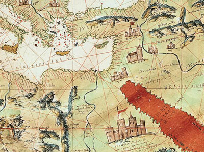
This manuscript differs significantly from Vespucci's double-hemispheric world map with polar projection printed in 1524. The Hispanic Society map is constructed as a portolan chart with compass roses and rhumb lines across the entire surface. The chief compass rose, which extends into Mexico, illustrates the Portuguese influence in cartographic ornamentation during the sixteenth century. As can be seen here, Africa, southern Europe, and Asia Minor are well known, also the coasts of Florida, Mexico, Central America and northern South America. On the east coast of the present United States, another Florentine, Giovanni da Verrazzano, has been credited with claiming New England for Francis l of France and for discovering New York Bay in 1524. Estêvão Gomes, a Portuguese pilot in the service of Spain, explored the coast as far north as Maine and the Penboscot River (R:desgamos). Vespucci himself had attended the meeting at Badajoz which authorized this expedition. The Bacalaos, now known as the Grand Banks, Cape Race in Newfoundland, Stag River and the land of the "bartoas" are recorded by Vespucci, along with the new land of Ayllón. This first settlement within the boundaries of the United States had been made by Lucas Vazquez de Ayllón of Toledo near the Santee River (R:Jordan) in South Carolina.
The map is also notable as an expression of empire in 1526. Charles V's imperial coat of arms is placed above North America while flags of Castile and Leon (gold castles on a red ground and brown lions on a white ground) mark Spanish territories just as the Portuguese ones do for their holdings. Moreover, Vespucci includes many engaging details: eight galleons sailing the ocean, the Red Sea painted red, the tower of Babylon located in Persia, elephants and camels in Africa, and the churches of the Holy Land.
Text and images © Hispanic Society of America.