

Archaeology

Is Seneca Village an archaeological site?
One of the main questions we have asked about Seneca Village is whether or not archaeological traces of it survived the creation of the romantic landscape of Central Park and still exist in the park today. As archaeologists we know that we could find out a lot about the lifeways of the people who lived in Seneca Village by studying the artifacts they left behind. But the workers who made the park in the 1850s and 1860s moved a lot of dirt. In some cases they made the ground higher by bringing in landfill; in others they made the ground lower by grading soil away; and in others still they left the soil relatively intact. If they graded soil away, they destroyed any archaeological site that might have been there. But if they brought in landfill and deposited it on top of the natural soil, or if they left the natural soil undisturbed, then the Seneca Village archaeological site could still exist. So we needed to find out about the soils in the village area to find out if the site was still there.
Geoarchaeological study: are the soils undisturbed?
We found a soil map that had been made of the park in the 1980s. The map suggested that while in some places in the village the soil had been disturbed, in others it was intact. But the scale of the map was large, and it was not clear how accurate it really was. So in the spring of 2004 we began to work with geoarchaeologist Suanna Selby. Geoarchaeology is a form of study that uses geological techniques to evaluate archaeological sites. We knew that if we could get samples of soil from the village area by digging cores, Suanna could look at the soil in the samples and tell us whether it had been disturbed (thus destroying the archaeological site) or whether it had naturally formed in place (indicating the site had been preserved). Working with Suanna, we took the soil map and superimposed it over an old map made by Gardiner Sage that showed the locations of the houses in the village. We then designed our sampling plan: we drew four transects where the soil map indicated that the soil was not disturbed and where the Sage map showed houses; it was in those areas that we thought we were most likely to find archaeological traces of the village.
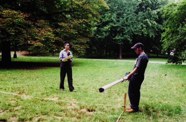
After getting permission from the New York City Department of Parks and the Central Parks Conservancy, we went out into the field every Friday during the fall of 2004 with ten ? students from local universities. Suanna taught the students to use augers to take the samples, which were each 3-4" wide and 8x10" long. The students screwed the auger into the ground and pulled out each sample for analysis. They repeated the process over and over again, with the cores going deeper with each successive coring. They retrieved the samples until the auger could go no further because it had hit an obstruction, which was usually bedrock. They spread the samples out on a tarp and, under Suanna’s supervision, analyzed them.
Suanna and the students discovered that there was undisturbed soil in two of the transects, transect 3, along the south side of 84th Street, and transect 4, along Seventh Avenue (as these streets might extend into the park). In addition, they discovered that there were artifacts present in some of the samples. The artifacts ranged from the mundane – pieces of coal, brick from chimneys, or nails, for example – to the exotic – pieces of plates or bottles... It looked as if parts of Seneca Village still existed as an archaeological site!
Ground penetrating radar: are there archaeological features there too?
Although it looked as though parts of Seneca Village had been preserved as an archaeological site, we needed to confirm that further. Archaeological sites of course are made up of layers of soil that contain artifacts, but they are also made up of features–non-portable artifacts like buried foundation walls or cellar floors or re-filled holes in the ground which might have been used as trash pits or latrine shafts–which archaeologists cannot bring back to the lab. They can bring back the stones that make up the wall or the fill from the hole, but not the wall or the hole itself. If we were going to plan an excavation at the site, we needed to know where the house foundations and other features were, so that we could decide where to place our excavation units. There are several techniques that archaeologists use to find features under the ground without actually digging. We learned from earlier work with geophysicists Bruce Bevan and Roelof Versteeg that ground penetrating radar was the most appropriate one for Seneca Village.
So in the summer of 2005, we arranged to work with geophysicist Larry Conyers and graduate students from Columbia and the City University, and spent three days conducting ground penetrating radar at the site. The principle behind this technique is that as radar equipment is run back and forth along parallel grid lines (in this case, at one meter intervals), it sends an electromagnetic pulse down into the ground. By measuring the time that elapses before the pulse echoes back to a receiver, it is possible to locate objects underground that are anomalies in that they are either more or less dense than the surrounding soil matrix. The goal of using this non-invasive technique at Seneca Village was to determine whether or not there were possible archaeological features (such as building floors, which would be more dense, or privy shafts, which would be less dense, compared to the surrounding soil) in the areas where Suanna had found what appeared to be intact soil layers, and also to see if possible burials could be located on the church properties in the Village. Larry discovered anomalies in eight living areas, including what appear to be a total of four floors, one privy shaft, and several middens, as well as several grave shafts in the area of African Union Church. FIG His study confirmed Suanna's findings and indicated that there were intact features in parts of the site as well.
Digging Seneca Village: how would we plan our excavation?
Now, we want to conduct archaeological test excavations at the site to confirm or "ground truth" the interpretations made from the soil and radar testing. We would also like to get a sample of the artifacts used by the Seneca Villagers so that we can find out more about their ways of life.
We would like to excavate over a two month period in the early summer, working with a crew of about a dozen students. We hope to excavate several units in each of the sensitive areas where the ground penetrating radar study found several possible features in the residential parts of the village. We do not want to excavate in the area where Larry picked up the presence of possible burials, because excavating burials is offensive to many modern-day African-Americans.
Because Central Park is such a heavily-used public space, we will confine the excavations at any one time to just one of the sensitive areas that Larry found. We plan to secure each area where we work with fencing, so that passersby do not accidentally fall into the holes. Each night we will cover the units with sheets of plywood. We will also have a security guard on site whenever there are open excavation units and the archaeologists are not there, to protect the site from vandals and the public from injury.
Each excavation unit will be dug the way archaeologists usually dig today. We will first remove the sod and try to preserve it for replacement. Then, we will excavate each unit stratigraphically, soil layer by soil layer, down to the level where culturally sterile soil (i.e., soil without artifacts) or bedrock is reached. We expect that the deepest units will not be more than about one and a half meters deep, and that most will probably be less. The different soil layers, which are distinguished from each other by differences in color and/or soil texture, were deposited at different times as part of different events; for example, one layer might have been dropped by water flooding from a river while another was garbage that someone left on a basement floor. Therefore we will keep the artifacts and other samples from each layer separate for analysis. The excavators will use shovels when possible and trowels for finer work.
Each excavation unit will be assigned a letter designation (A, B, C, etc.) and will be tied into a site map. The excavators will make scale drawings (profiles or section drawings and plan views) and take photographs of both the layers of soil as revealed in the walls of the excavation units and in overviews. If we find features, such as walls or floors, we will photograph and draw them and then decide whether to remove them or leave them in place (or in situ). If we find what appears to be a midden or garbage dump, we will excavate it as a unit, after photographing and describing the feature.
All of the soil from each unit will be sifted or screened through 1/4" wire mesh, leaving the artifacts behind in the screen so that they can be retrieved. Any large or delicate artifacts will be photographed in situ before being removed, and a conservator—someone trained to preserve artifacts—will work on the delicate ones. We will store the sifted dirt in piles on tarps next to the unit it came from. At night, we will cover both the excavation units and the dirt piles with tarps to protect them from rain. After each unit is finished, we will backfill the soil into it and replace the sod on top.
After we've finished the excavations and on rainy days throughout the field season, the crew will work in the archaeology lab. There, they will clean the artifacts by washing or brushing them and write numbers on them that will indicate the site, excavation unit, and the layer of soil where they were found. Then, they will check to see if any of the artifacts mend together, so that sherds will be put together to form dishes, etc. Finally, they will catalogue and identify the artifacts, figuring out when they were made, what they were used for, etc. We anticipate that, using a ratio of 2:1 for estimating time needed in the lab in relation to time spent in the field, we will need approximately 800 people days in the lab.
In keeping with our educational policy, we plan to use archaeology students as archaeological technicians throughout the project. FIG During the field phase, for example, we anticipate having a crew of two undergraduates working with a graduate student at each of the excavation units, and students will continue to work in the laboratory. We also plan to establish a partnership with one or more New York City public schools and involve students from these schools in the field and the lab.
The archaeological study of Seneca Village is important!
First, it offers the opportunity to understand a group of middle-class African Americans, about whom we can learn only a little by studying historical documents. What were their lives like during the 19th century? Second, the community is also important because it was the home of Irish immigrants as well as African-Americans; did these two groups form one community or two separate ones? Third, the act of studying the community, whether through historic documents or archaeology, offers respect to its residents and their descendants, a respect they were denied when they were displaced with the creation of the park. The project has specific research questions that we hope we will be able to address (depending on the kinds of artifacts we find), but we believe that remembering and recognizing Seneca Village is as important as the research itself.